The most famous view of Milford Sound, shown above, is of the steep-sided Mitre Peak (1962m, and actually five closely grouped peaks) sitting imposingly in the middle of the sound. However, this is only one view -- each direction is afforded spectacular views of snow-capped steep mountains, waterfalls, and deep green tanin-filled waterfall-fed ocean. It's impossible to see the open water of the Tasman Sea around the 16km of curves (and other mountains like the Elephant and the Lion), and the flat, calm waters bely its connection to the rough and windy western coast.
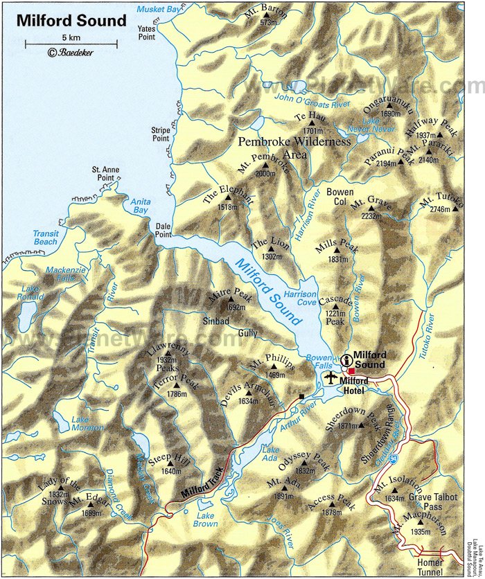
The town of Milford (population 120) lies on a small area of marshy land at the head of the sound where the Cleddau, Tutoko and Arthur Rivers empty into the sea -- there is nowhere else the town really could be and it is one of the few sounds that has land suitable for a settlement. It includes an airstrip from which frequent scenic flights depart, a cruise terminal and jetty, and an old THC Hotel, but not really much else. Similar to Doubtful Sound (#729), its less famous neighbor, and the other 12 sounds, it is part of the Fjordland National Park and Te Waipounamu, the UNESCO World Heritage Site. However, it is the only sound in the park with road access for tourists.
www.planetware.com
For years, Milford Sound was only accessible by sea or by foot, until the famous 1.2km Homer Tunnel was opened in 1954 (it was begun in 1935) under the Darran mountain range. Milford is still very inaccessible, with the one road going in that's often snowed under in winter. It's 2 hours (121km) to the nearest town, Te Anau.
The wettest place in New Zealand, snow remains even in summer.
While the Maori have used the MacKinnon Pass (found in 1888 and made part of the Milford Track) to access the sounds to collect pounamu (greenstone) for around 1000 years, and called it Piopiotahi after the place of mourning of the "first" now extinct Piopio bird and the legend of Maui's death trying to win immortality for mankind, it wasn't until John Grono landed in 1812 that it was named Milford Sound after Milford Haven in Wales. Rudyard Kipling apparently called it the 8th wonder of the world!
The Eglinton Flats, along with the Te Anau Downs are the beginning of a road journey into Milford.
The Gleddau River
The landscape right outside the Homer Tunnel - Keas love it here!
The Chasm is halfway between Milford and the Homer Tunnel and gives an idea of the quantity of rainfall and the force of the water carving the valleys (although the sound itself was formed by a glacier during the last ice age.
The river marshes around Milford afford excellent bird watching!
Waiting in line for the single-lane Homer Tunnel on the
Milford Side, while keas pester tourists and land on cars.
Number one on roads to see before you die, I can agree that it is a spectacular drive! This "most adored" of California's highways, took 18 years to build (as part of the Depression Era's New Deal), and most of its residents didn't get electricity until the 1950s. The Spanish bypassed it for being too rugged (they called it "el pais grande del sur" or the big country of the south, and until the road was built in the 1930s, it was one of the most remote parts of California. Aside for the famed 85km stretch of winding Highway 1 - which is NOT a freeway so take time -- there's a castle, sea lions, birds, redwood forests and many beautiful beaches and trails to see and walk.
From the Monterey Peninsula and Carmel in the north to San Simeon in San Luis Obispo County in the south, the road follows the Santa Lucia Mountains as they rise sharply from the sea (Big Sur's Cone Peak is the largest coastal mountain in the contiguous United States at 1571m).
Hearst Castle
The history of the area starts with the Native American Ohlone, Esselen and Salinan tribes, who left few artifacts aside from obsidian and flint arrowheads. The Spaniards sailed past in 1542, but chose to settle further inland where several Catholic Missions can be found. It was part of Mexico after their independence from Spain in 1821, but was ceded to the United States after the Mexican-American War in 1848. The 1862 Homestead Act brought hardy settlers who were granted plots of 160 acres, and many of the region's names date from this era and these families. The Gold Rush era saw the cutting down of many redwoods and the establishment of various landings and camps (as there were no reliable roads), but most of these have disappeared today. In 1894 the SS Los Angeles ran aground near Point Sur light station, but its inaccessibility encouraged politicians to propose a road.
The road was approved in 1919 and construction began with convict labor from San Quentin Prison. The route included 33 bridges (Bixby Bridge is the largest) which became part of the National Register of Historic Places in 1986. Originally Route 56 when it was finished in 1937, it was re-designated Highway 1 in 1939.It was the first State Scenic Highway (in 1965) and also holds the title of All American Road.
Relative isolation in the mid 20th Century brought artists and hippies, from Jack Kerouac to Henry Miller and Hunter S Thompson. Elizabeth Taylor and Richard Burton also filmed The Sandpiper in the area, and bands from the Beach Boys to the Red Hot Chilli Peppers have eulogized the area in songs.
Los Padres National Forest is a unique ecosystem in the middle of the otherwise quite barren area.
The road is sometimes closed due to landslides and the seasonal California fog is a frequent visitor.
The most famous view of Big Sur is this view of Bixby Bridge, built in 1932.
View from the entrance to Skipper's Road from the Coronet
Peak Road looking back towards Arthur's Point, the back of
Queenstown Hill, Queenstown itself tucked into the valley,
and Lake Wakatipu with Cecil Peak behind.
Just out of Queenstown (#998) is an old miner's town, now a ghost town. It is also one of my favorite drives in the country. We have always had a 4WD, so it was the place we always took our guests. Now, most people go in on some kind of tour (cycling, jetboating, bungy jumping, etc!).
Skipper's is famous for its peaked brown landscape with tussock growing over the hills (this is very typical of Central Otago). While some parts of the region are slowly being taken over by introduced pine trees, I don't agree with NGO Wilding Pines' method of spraying them which looks worse than the trees and leaks poisonous sprays into rivers.
As Dangerous Roads says, the 16.5km 1880s road built to replace a small track during the gold rush days "is so narrow that if two vehicles have to pass each other, one vehicle might have to reverse for anything up to 3 kilometres of winding narrow road to get to a place wide enough to pass. It’s one of only two roads in the country where rental car insurance is not honoured if driven on. Skippers Road is mostly one-way, narrow and steep with sheer drops of several hundred metres." Soon after you cross the pass from the Coronet Peak Road, you come to the aptly named Hell's Gates, for example.
The canyon itself was carved glaciers over 25,000 years ago and further refined by the Shotover River. Significant numbers of settlers first came to the area in the late 1860s after Thomas Arthur and Harry Redfurn found 4 ounces of gold in 3 hours near the appropriately named modern spot of Arthur's Point. Near the subsequently named Maori Point, 300 ounces was discovered on one beach in a day after two Maori miners (Dan Ellison/Raniera Erihana and Hakaria Maeroa) tried to cross (almost losing their dog in the process). This area later became a boom town called Charlestown.
I once heard that the Shotover River had more gold mined from it than any other river in the world, and all the tourist websites in Queenstown love to say that it is the 'richest gold-bearing river in the world' except one which says it is the second richest, and another says that it's only the richest for its size, and another gives this fame to the connected Kawarau River, but I can't find any data online to back up this claim and wikipedia says since the quantity of gold was never accurately measured its impossible. It is true, however, that due to the erosion on the hills surrounding Skipper's and the alluvial nature of the river itself, significant amounts of gold could be obtained from panning, which is usually only used for prospecting.
Irishman "Skipper" Malcolm Duncan (who worked on American ships to earn his name) first discovered gold at Skipper's Creek, later to be Skipper's Point or simply 'Skipper's' and it was here and at Mt. Aurum Station that the most buildings remain. Working the claims until the 1900s, their water races, holding dams, sluicings and tailings are still visible today. Aside from this, the main sites to see are the Mt. Aurum Homestead, the Skipper's school and the cemetery.
It took around 20 years of horse-tracks and lost horses before demand for the road was sufficient. It was built over seven years by 4 contractors. Initially, motor cars were prevented from using it, and later, restricted permits had to be obtained in order to drive on it. It was made a New Zealand Historical Site in 2006. The Skipper's suspension bridge (2.2m wide, 96m long, 90m high) was not built until 1898, long after the main gold rush was finished. It replaced another suspension bridge built closer to the water.
Further up the Skipper's road was Bullendale, site of the first electricity used in New Zealand.
Skipper's School was renovated in 1992.
Inside the school house.
The schoolhouse before renovation
Skipper's Bridge before the trees grew!
Skipper's School house in its heyday.
Welcome Home Inn, Skipper's is no longer standing, but its chimney is!
The Otago Hotel in Aspinall's Terrace, half way up the Skipper's Road.

 The most famous view of Milford Sound, shown above, is of the steep-sided Mitre Peak (1962m, and actually five closely grouped peaks) sitting imposingly in the middle of the sound. However, this is only one view -- each direction is afforded spectacular views of snow-capped steep mountains, waterfalls, and deep green tanin-filled waterfall-fed ocean. It's impossible to see the open water of the Tasman Sea around the 16km of curves (and other mountains like the Elephant and the Lion), and the flat, calm waters bely its connection to the rough and windy western coast.
  The town of Milford (population 120) lies on a small area of marshy land at the head of the sound where the Cleddau, Tutoko and Arthur Rivers empty into the sea -- there is nowhere else the town really could be and it is one of the few sounds that has land suitable for a settlement. It includes an airstrip from which frequent scenic flights depart, a cruise terminal and jetty, and an old THC Hotel, but not really much else. Similar to Doubtful Sound (#729), its less famous neighbor, and the other 12 sounds, it is part of the Fjordland National Park and Te Waipounamu, the UNESCO World Heritage Site. However, it is the only sound in the park with road access for tourists.