Tuesday, December 30, 2014

#643 Saint George's, Bermuda

St. George's Town was first settled in 1612, the first permanent British settlement on the islands of Bermuda and its capital until 1815. Some claim it is the oldest continually inhabited English city in the New World. Originally called New London, it was a stopping place for the ships of the Virginia company on their way to Jamestown and other settlements.
Ordnance Island is connected to St. George's by a short causeway, and much of the waterfront is reclaimed land.
With quaint names and narrow alleys, the town is fun to visit, and prettily decorated in a traditional style, with the typical Bermudian water-collecting roofs on display.

The main town square, King's Square, is bounded by the 1782 Town Hall to the east, the Bermuda National Trust Museum to the north-west, and Ordnance Island.
The location of hangings, Ordnance Islands guns signify its past, but is now used as a cruise ship terminal.
A replica of the Deliverance, one of two boats built by survivors of the 1609 shipwreck Sea Venture that was stranded (deliberately sent onto the reef) on Bermuda on their way to Jamestown, VA, and led to the first settlers of the islands.
Other historic landmark sites to see in the town include the first stone building, the 1620 State House, the Old Rectory, St, Peter's Church, the Tucker House, and the Mitchell House (housing the St. George's Historical Society Museum, and the Featherbed Alley Printshop Museum), along with the oldest structure on the island, the L-shaped Bridge House. Along with its fortifications, it was designated a UNESCO World Heritage Site in 2000.
The unfinished church is above and behind the town on a hill. Construction began in 1874 after the town's main church, St. Peter's was damaged in a storm. The local populace was divided, however as to whether to repair the old church or construct a new one, so it was never finished. In 1926 a bad storm significantly damaged what was there. It is closed to the public for safety reasons, but you can peek through a window like me!
Source: http://www.bermuda-attractions.com/bermuda2_000027.htm
http://en.wikipedia.org/wiki/St._George's,_Bermuda
http://www.bermuda-attractions.com/bermuda2_000028.htm
http://whc.unesco.org/en/list/983

Sunday, December 28, 2014

#644 Giant's Causeway, Northern Ireland, UK

It is easy to see what this magnificent natural formation is a UNESCO World Heritage Site. It has inspired and sustained legends and while there are similar formations (like Fingal's Cave on Scottish isle Staffa on the other side of the sea), it is unique. At most 12 meters high and around 28 meters thick in the widest places, they were formed during a volcanic eruption during the Paleogene period 50-60 million years ago as the lava cooled near the limestone forming a similar structure to dried, cracked mud. However, the stones just form part of a 3800 square kilometer area including the surrounding 100m cliffs, which form the largest remaining lava plateau in Europe.

Part of the Antrim peninsula in Northern Ireland, people have been visiting as tourists since the 1693 'discovery' by the Royal Society. It was a popular feature on The Grand Tour as well, popularized by Miss Susana Drury's paintings.
An aerial photo from the http://www.giantscausewayofficialguide.com/ website.

The coastline is dotted with similar coves,all part of the same formation, although not all have the unique columns!
Known as Clochán an Aifir or Clochán na bhFomhórach in Irish, it's name comes from the legend of Fionn mac Cumhaill, who built the causeway when he was challenged to a fight by Scottish giant Benandonner. Benandonner was tricked when he discovered when Fionn's wife Oonagh pretended he was a baby. From the size of the Fionn 
'baby' and speculation as to the size of the father, Benandonner fled to Scotland in fright, destroying the causeway behind him. so that Fionn couldn't follow.

Seen from above.
Unfortunately, a rainy day when wen went!
Stepping stones as perfectly fit together as in a jigsaw puzzle. There are supposed to be around 40,000 interlocking basalt columns, most of six sides (hexagonal), but a few with more or less.
The narrow gap between the causeway and the mainland. Other features at the site include a 'Giant's Boot' and an 'organ' (stacks).
Sources: http://en.wikipedia.org/wiki/Giant's_Causeway
http://whc.unesco.org/en/list/369
http://www.giantscausewayofficialguide.com/

Saturday, November 29, 2014

#645 Milford Sound, New Zealand

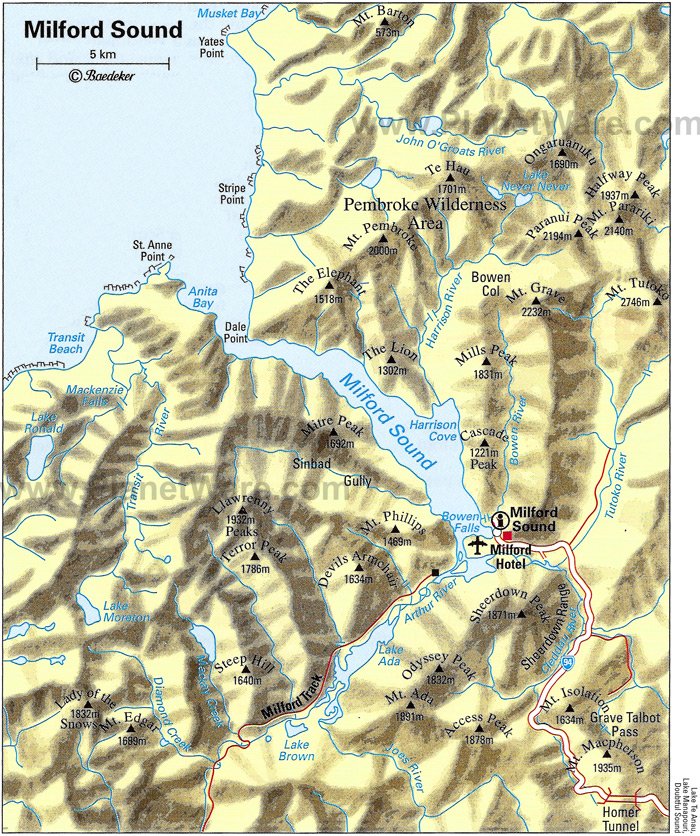
The most famous view of Milford Sound, shown above, is of the steep-sided Mitre Peak (1962m, and actually five closely grouped peaks) sitting imposingly in the middle of the sound. However, this is only one view -- each direction is afforded spectacular views of snow-capped steep mountains, waterfalls, and deep green tanin-filled waterfall-fed ocean. It's impossible to see the open water of the Tasman Sea around the 16km of curves (and other mountains like the Elephant and the Lion), and the flat, calm waters bely its connection to the rough and windy western coast. 
The town of Milford (population 120) lies on a small area of marshy land at the head of the sound where the Cleddau, Tutoko and Arthur Rivers empty into the sea -- there is nowhere else the town really could be and it is one of the few sounds that has land suitable for a settlement. It includes an airstrip from which frequent scenic flights depart, a cruise terminal and jetty, and an old THC Hotel, but not really much else. Similar to Doubtful Sound (#729), its less famous neighbor, and the other 12 sounds, it is part of the Fjordland National Park and Te Waipounamu, the UNESCO World Heritage Site. However, it is the only sound in the park with road access for tourists. 
www.planetware.com
For years, Milford Sound was only accessible by sea or by foot, until the famous 1.2km Homer Tunnel was opened in 1954 (it was begun in 1935) under the Darran mountain range. Milford is still very inaccessible, with the one road going in that's often snowed under in winter. It's 2 hours (121km) to the nearest town, Te Anau.
The wettest place in New Zealand, snow remains even in summer.
While the Maori have used the MacKinnon Pass (found in 1888 and made part of the Milford Track) to access the sounds to collect pounamu (greenstone) for around 1000 years, and called it Piopiotahi after the place of mourning of the "first" now extinct Piopio bird and the legend of Maui's death trying to win immortality for mankind, it wasn't until John Grono landed in 1812 that it was named Milford Sound after Milford Haven in Wales. Rudyard Kipling apparently called it the 8th wonder of the world!
The Eglinton Flats, along with the Te Anau Downs are the beginning of a road journey into Milford.
The Gleddau River
The landscape right outside the Homer Tunnel - Keas love it here!
The Chasm is halfway between Milford and the Homer Tunnel and gives an idea of the quantity of rainfall and the force of the water carving the valleys (although the sound itself was formed by a glacier during the last ice age.
The river marshes around Milford afford excellent bird watching!
Waiting in line for the single-lane Homer Tunnel on the
Milford Side, while keas pester tourists and land on cars. 
http://www.milford-sound.co.nz/
https://en.wikipedia.org/wiki/Milford_Sound
https://en.wikipedia.org/wiki/Homer_Tunnel