Showing posts with label unvisited. Show all posts

Thursday, May 22, 2014

#673 Meda'in Saleh, Saudi Arabia

http://www.utaot.com/wp-content/uploads/2013/08/4938269.jpeg
http://www.hereandthere.eu/blog/madain-saleh-the-alternative-to-petra/
http://www.alshitaiwitours.com/pimage/Madain_Saleh.jpg
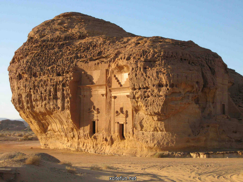
Somewhere I haven't been, but have wanted to visit ever since I first heard about it, Madain Saleh in Saudi Arabia is similar in structure to Petra (#873) just across the border in neighboring Jordan (Petra is 500km northwest). Part of the Hijaz mountains, it is located near the modern city of Ula (Al-Ula), which is 400km northwest of Medina. Its mention in the Quran makes it a sacred spot, but not somewhere that Mohamed encouraged people to visit because it was a place where God's wrath had been demonstrated. The Quran places the settlement of the area after Noah but before Moses (3rd Millenium B.C. approximately).
http://www.iqrasense.com/islamic-history/madain-saleh-cities-inhabited-by-the-people-of-thamud.htm
The name translates to the city of the prophet Saleh, and is also known as Al-Hijr ("rocky place") or Hegra. It belonged to a group of people from Thamud, and prophet Saleh was send to save them from their idolatrous ways, but they disobeyed even though Allah sent a sacred pregnant female camel which they slaughtered, and thus they were cursed and killed by an earthquake and lightning.
http://img.xcitefun.net/users/2010/12/220314,xcitefun-madain-saleh-3.jpg
Western archaeologists believe the city's main constructions were built by the Nabataens, but Muslims believe they were significantly older than this. There is also evidence of Liyhanite and Roman settlement in the area, before and after the Nabataens, respectively. Some pre-Nabataen cave art exists on Athleb Mountain. The Romans annexed the Nabataen kingdom in 106 A.D. The Ottomans had a fort here to protect the Hajj route from 1744 to 1757, and later they built the Hejaz Railway through the area. Minimal archaeological projects have been undertaken, but recent pushes by the Saudi Arabian government for recognition of heritage and cultural items along with the UNESCO status from 2008, have helped to protect the area.
Sources: http://www.iqrasense.com/islamic-history/madain-saleh-cities-inhabited-by-the-people-of-thamud.html

Sunday, May 26, 2013

#826 Umm Al-Aish Satellite Dish, Kuwait

www.evidence.org.kw
One place that I heard about when I was in Kuwait was the burned out satellite dish that remained in the desert of Kuwait after the war. The website 'Kuwait Invasion: The Evidence' has collected images of the Iraqi occupation of Kuwait and the destruction they rendered -- this is one example of that destruction.

The Umm Al-Aish area was used for telecommunications, including telephone and wireless for ships, planes, especially the military. Unfortunately, I never saw it for myself and now it's too late. In 2009 the Kuwaiti government dismantled the two satellite dishes to sell for scrap metal, which is too bad as it was popular to visit and an important monument to their struggle against their neighbor.
www.evidence.org.kw

www.evidence.org.kw
Source: http://www.evidence.org.kw/photos.php?page=4001_Umm-Al-Aish-Satellite-Dish
http://www.arabianbusiness.com/kuwait-scraps-obsolete-satellite-station-41095.html

Friday, March 29, 2013

#851 Marianas Trench

deepseachallenge.com 
Ever since I was young I've been fascinated with the Marianas trench. The diagram above helps to show why I always found it so amazing -- we always thing about the highest point, Everest, but we rarely think about how deep the earth goes inwards, and the fact that the earth goes further inwards than it does outwards is really quite incredible. At almost 11km deep (5960 fathoms) at 'Challenger Deep' at its southern end, it is further into the earth than we can go outward although both extremes suffer from too much pressure -- altitude sickness, oxygen deprivation, atmospheric pressure, etc. I just wish it wasn't so inaccessible! 

And even though there are areas of the Arctic ocean floor that go closer to the earth's core (because Earth is not a perfect sphere and the Marianas is at its widest point in the tropics), it is a phenomenal place.

Cool facts:
  • It is 1 to 4 degrees C at the bottom.
  • Xenophyophores are a microbial bacteria life form found deep in the trench.
  • The Marianas Islands were claimed by Spain in 1668.
  • The trench was first 'sounded' in the 1870s.
  • In 1995, an unmanned remote controlled Japanese vehicle completed the deepest dive on record.
  • Four manned descents have been made, the first in 1960, and the most recent by director James Cameron in 2012.
  • Sole, flounder and shrimp have been observed at the bottom.
  • It has been proposed as a place for nuclear waste disposal, in hopes that the tectonic movements will eventually push the waste under the earth and into the earth's mantle. Thank goodness it's prohibited by international law!

Friday, March 22, 2013

#855 Pink and White Terraces (Otukapuarangi), New Zealand

painting of Pink & White Terraces
John Clarke Hoyte painting. Pink and White Terraces, Lake Rotomahana and Mount Tarawera. Watercolor and gouache on paper. ca 1870s. Hocken Collections. Uare Taoka o Hakena, University of Otago.
http://www.whoi.edu/oceanus/viewImage.do?id=223993&aid=135809
This is an unusual one: The pink and white terraces are an amazing place -- however they no longer exist. Actually, they no longer exist in the form that made them famous.

http://www.buriedvillage.co.nz/pink_and_white_terraces/p/49
The pink and white terraces were two sets of beautiful geyser formations of silica terraces in Lake Rotomahana near the dormant volcano Mt. Tarawera, around 25 km south of the New Zealand town of Rotorua, but they disappeared during an 1886 eruption of Mt. Tarawera. 800m apart, it is thought they had different appearances because of the amount of sunlight they each received, with the white ones being the larger set, around 50 layers and cascading over 40m in height, and the pink ones being the preferred area for swimming.

"The journey from Auckland was typically by steamer to Tauranga, the bridle track to Ohinemutu on Lake Rotorua, by coach to Te Wairoa by canoe across lake Tarawera, and then on foot over the hill to the swampy shores of Lake Rotomahana and the terraces." (Wikipedia)
photo
http://www.virtualoceania.net/newzealand/photos/volcanic/terraces/whiteterraces.shtml
The eruption at 3am on 10 June 1886 caused the lake floor to explode, showering the area with liquid mud, ash, stones and other debris, not only reclaiming the terraces, but burying two Maori villages, Moura and Te Ariki. After the eruption, there was a crater where the terraces had been, which was eventually filled with the water of the lake

Water Basins photo
http://www.virtualoceania.net/newzealand/photos/volcanic/terraces/waterbasins.shtml
In Maori they were known as Otukapuarangi, "fountain of the clouded sky" and they were a popular tourist attraction from the 1840s, especially after Prince Albert, the Duke of Edinburgh, visited in 1870, but were a source of racist resentment from the white (pakeha) New Zealanders because the Te Arawa tribe that owned them became wealthy from their control and ownership of the area (they even had their marae (meeting house) in Hinemihi made with gold florins instead of paua (abalone shell) eyes. After the eruption killed and displaced members of the tribe, the New Zealand government unfairly converted the area into crown land in a payment-for-relief-assistance system, although much of this (including 13 lakes in 2006) has been returned to the tribe in the past decades as part of the Treaty of Waitangi tribunal.

Lake Tarawera photoLake Tarawera photo
Lake Tarawera before the eruption and today -- the eruption enlarged the lake. A narrow isthmus separates lakes Tarawera and Rotomahana.

I've been fascinated with the pink and white terraces since I was a girl and saw a beautiful painting of them. It was only after a while that I learned that they had been destroyed -- I had dreamed of visiting them!

In a marvel of modern science, the lowest two tiers of the pink terraces were rediscovered 60 metres underwater while mapping the lake floor in 2011, and it is thought that the rest may be buried under sediment, and the increased-level lake.

Saturday, August 18, 2012

#948 Kamchatka Peninsula, Russia

A place that I've always wanted to visit, but prohibitively expensive and quite inaccessible: Kamchatka Peninsula. People tell stories of only being able to visit the remote volcanoes by helicopter, and that the number of active volcanoes is unmatched anywhere in the world, but these are just rumors of a place so remote and unvisited that people will say anything about it. Unfortunately, I haven't yet had the pleasure to visit, so I can't dispute any rumors yet, but I wanted to share this amazing place with everyone, so that you can add it to your bucket list, too!
http://izismile.com/2012/06/29/2012s_most_spine_tingling_photos_so_far_49_pics-2.html
You may have seen this incredible photo of a lava flow cave inside a glacier in email forwards and circling the internet. What a place!
From telegraph.co.uk where they advertise Kamchatka as being an option for a 'Blackberry-free break'!
File:Akademia nauk.jpg
The Kamchatka peninsula would have a similar temperature range to southern Alaska, and with only around 300,000 people in an area similar to that of Japan, it is easy to see why it is off the beaten path despite being an UNESCO World Heritage site. The Eastern side catches the storms and remains covered in snow even in summer, but in winter it is girded with ice and even has oceanic ice bracketing the ports.

Part of the Pacific's Ring of Fire caused by the tectonic plates' collision, in addition to its many volcanoes there is the 10,000 meter Kuril-Kamchatka Trench just off the eastern coast. Of the 160 volcanoes, 29 of them active, and 19 included in UNESCO's list.

I want to visit this spectacular landscape and see the amazing semi-arctic wildlife and landscape.
File:Kamchatka Peninsula.jpgFile:Sea Ice Imitates the Shoreline along the Kamchatka Peninsula.jpg

Note: Photos are not mine -- many are from Wikipedia.

Thursday, June 21, 2012

#971 Uluru (Ayer's Rock), Australia

New 7 Wonders website (nature.new7wonders.com)
The amazing sandstone formation in the center of Australia, Uluru (Ayer's Rock) is an amazing geological feature, important cultural icon, sacred Aboriginal site, and a spectacular natural area. Located in the middle of the outback wilderness, 335km from the nearest town, Alice Springs, the site includes springs, waterholes, rock caves and ancient paintings. It's so wonderful when the biggest symbol for a country is something natural and impressive!
Uluru from above -- from Wikipedia.

Sunday, June 3, 2012

#979 Preacher's Rock, Norway

Known as Preacher's Rock, or Preikestolen, this phenomenal rock sits 600m high above the Lysefjorden. Originating in the last ice age when the glacier that formed the fjord touched the edge of the rock and broke off large chunks. Ice formed cracks in places that remain. After a walk of around 3km, tourists emerge on the flat rock surface, daring to go as near to the edge as they can! What a beautiful spot.

I have not visited this beautiful place -- these photos are courtesy of my father, Brian Marquand.