

In the middle of Fjordland's amazing 14 sounds, Doubtful Sound is the longest. It has three arms, Hall, Crooked and First Arm on the southern side of the fjord, with Thompson and Bradshaw Sounds connecting to the north.
Named by Captain James Cook in 1770 because as he sailed by in the
Endeavour he 'doubted' that an exit would be easy due to the very steep/high mountains preventing a breeze from blowing and knowing that Easterlies (needed to get out of the sound) were rare! (This was in spite of begging by the naturalist Joseph Banks who wanted to collect samples.) It wasn't until 23 years later that the sound was explored by Spanish Alessandro Malaspina, who actually sent hydrographer Don Felipe Bauza to land on Maracaciones Point, and of course this island is now named after him. Many other Spanish place names remain in the sound as a legacy from this trip (Febrero Point, Pendulo Reach, Malaspina Reach).
In order to get to Doubtful Sound (aside from sailing into it from the Tasman Sea), you have to take a short cruise across Lake Manapouri to West Arm, past the powerstation, over Wilmot Pass (a unique piece of road in itself in that it is connected to no other road in New Zealand, and is the most expensive road in the country), before arriving at a small jetty in Deep Cove.
The mountainsides are so steep that there really isn't a place where a jetty can be built for the many ships that come into the sound, so the platform that is currently used does not actually go to the bottom of the sound but angles back into the cliff sides.
.png)

Formed by glaciers millions of years ago, Doubtful Sound is 430m at its deepest point and around 90m where it has shallow sills. Tides affect the sounds, but the variation of depth only ranges from between 2.5 and 3m. While the water has an average of 11 degrees Celcius, in the shallower places it can reach as high as 15 degrees.
At various times home the area has been home to a quartz mine, whalers, sealers, the crew building the Manapouri powerstation over Wilmot Pass, fishermen, and now, mostly tourists. Maori legend says that the sound was created by the godly figure
Tu-Te-Raki-Whanoa who came wielding a magical adze, fashioning long inlets as protection from the stormy seas. When he created Doubtful Sound (Patea) he was assisted by four young sea gods
Taipari, who created the arms.

Wildlife is the main reason people come to Doubtful Sound. The rare crested/tawaki penguin can be found here, along with the blue penguin, who can usually be seen swimming in the water, as can the resident pod of 60 bottlenose dolphins. Fur seals are seen at the Nee Islets near the entrance to the sound, and many different types of whales and orca occasionally venture into the sound. Temperate rainforest (only found elsewhere in the world in Patagonia and the US/Canadian Pacific Coast) means dense jungle vines, plants and ferns, which blend well with the beech (tawhai), and other native trees. It is also a prime bird-watching destination.

The narrow passage between Bauza and Secretary Islands is the Te Awaatu Channel Marine Reserve, which is 30m in places and popular with divers. On the western side of Elizabeth Island, there is also the Taipari Roa Marine Reserve. Deep Cove's biodiversity has also been affected by the inflows of fresh water that are discharged from the Manapouri Underground Power Station on the other side of Wilcot Pass at the edge of Lake Manapouri. Grono Bay holds the remnants of an 1800s sealing station, but as the practice began to be stopped by the New Zealand government in 1875 and the season was closed permanently in 1946, little remains and preservation of nature is the priority. Connected to Mount Aspiring, Westland, and Aoraki National Parks, it is part of the UNESCO World Heritage area known as Te Waipounamu.

Manapouri village receives 1,143mm of rain a year, West Arm receives 3786mm, and Deep Cove had 5290mm. Why would you want to go in the rain? Because that is when you'll see the millions of waterfalls cascading down the sides -- there is no area of catchfall so what falls from the sky falls straight off the mountains. The clear, calm days are beautiful too because then the mirrored reflection of color shines back at you in lively greens, browns, blues and golds. Deep in the sound itself, the water is brown, stained by the tanin washing down from all the organic matter on the sides of the fjords. It is actually just the freshwater surface layer, which only partially mixes with the salty under-layer. This tanin also makes it difficult for light to filter down into the water, so black coral, which is normally only found below 40m, can be found as shallow as 10m, perfect for divers.

My trip to Doubtful Sound was an overnight cruise with
Real Journeys -- what a great way to experience such a beautiful place!

 The most famous view of Milford Sound, shown above, is of the steep-sided Mitre Peak (1962m, and actually five closely grouped peaks) sitting imposingly in the middle of the sound. However, this is only one view -- each direction is afforded spectacular views of snow-capped steep mountains, waterfalls, and deep green tanin-filled waterfall-fed ocean. It's impossible to see the open water of the Tasman Sea around the 16km of curves (and other mountains like the Elephant and the Lion), and the flat, calm waters bely its connection to the rough and windy western coast.
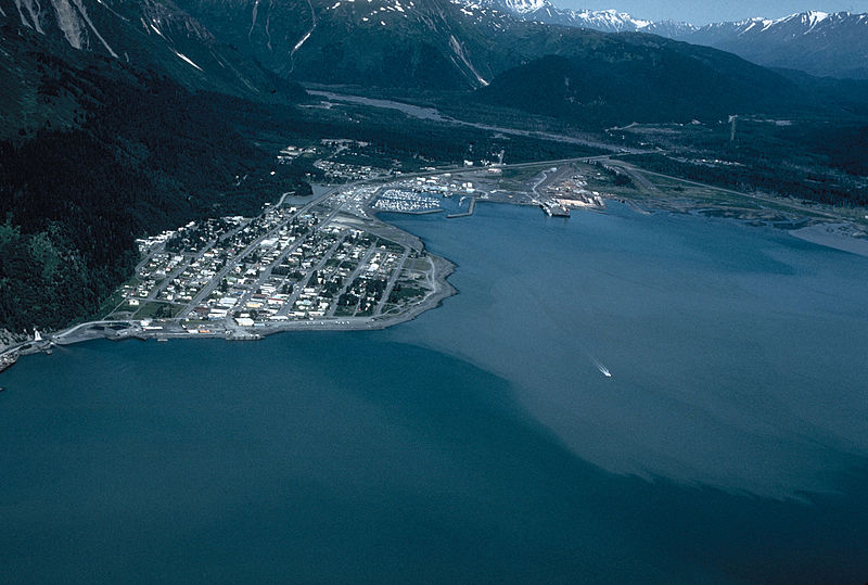
  The town of Milford (population 120) lies on a small area of marshy land at the head of the sound where the Cleddau, Tutoko and Arthur Rivers empty into the sea -- there is nowhere else the town really could be and it is one of the few sounds that has land suitable for a settlement. It includes an airstrip from which frequent scenic flights depart, a cruise terminal and jetty, and an old THC Hotel, but not really much else. Similar to Doubtful Sound (#729), its less famous neighbor, and the other 12 sounds, it is part of the Fjordland National Park and Te Waipounamu, the UNESCO World Heritage Site. However, it is the only sound in the park with road access for tourists.


