It is easy to see what this magnificent natural formation is a UNESCO World Heritage Site. It has inspired and sustained legends and while there are similar formations (like Fingal's Cave on Scottish isle Staffa on the other side of the sea), it is unique. At most 12 meters high and around 28 meters thick in the widest places, they were formed during a volcanic eruption during the Paleogene period 50-60 million years ago as the lava cooled near the limestone forming a similar structure to dried, cracked mud. However, the stones just form part of a 3800 square kilometer area including the surrounding 100m cliffs, which form the largest remaining lava plateau in Europe.
Part of the Antrim peninsula in Northern Ireland, people have been visiting as tourists since the 1693 'discovery' by the Royal Society. It was a popular feature on The Grand Tour as well, popularized by Miss Susana Drury's paintings.
An aerial photo from the http://www.giantscausewayofficialguide.com/ website.
The coastline is dotted with similar coves,all part of the same formation, although not all have the unique columns!
Known as Clochán an AifirorClochán na bhFomhórach in Irish, it's name comes from the legend of Fionn mac Cumhaill, who built the causeway when he was challenged to a fight by Scottish giant Benandonner. Benandonner was tricked when he discovered when Fionn's wife Oonagh pretended he was a baby. From the size of the Fionn
'baby' and speculation as to the size of the father, Benandonner fled to Scotland in fright, destroying the causeway behind him. so that Fionn couldn't follow.
Seen from above.
Unfortunately, a rainy day when wen went!
Stepping stones as perfectly fit together as in a jigsaw puzzle. There are supposed to be around 40,000 interlocking basalt columns, most of six sides (hexagonal), but a few with more or less.
The narrow gap between the causeway and the mainland. Other features at the site include a 'Giant's Boot' and an 'organ' (stacks).
The 11 or so kilometers of soft white sand that make up Grace Bay's beach are reported to be one of the best beaches in the Caribbean - in fact in 2011 and 2012, TripAdvisor users voted it the best beach destination in the world. If one was counting large resorts (30+), the presence of such a variety of places to stay would certainly convince you: from the Seven Stars, to Grace Bay Club, Club Med, the Somerset, the Venetian, Windsong, the Alexandria, the Sands or the all-inclusive Beaches, this is the destination for the island of Providenciales, plus there are also many smaller resorts and private residences.
Trying to capture its loveliness is difficult as every image seems similar - it's just so perfect. What is it that makes it great? The reef prevents any large waves so it is calm and safe -- surf lovers can look elsewhere on the island. The waters are a perfect, beautiful turquoise and blue, apparently from the purity of the white sand (which is so fine it acts like a glue on your feet!). There is world-class diving on the wall of the surrounding reef -- it is part of the third-largest barrier reef system in the world. Perhaps its so great because it seems no one has heard of it?
It got its start when Club Med built an exclusive hotel in 1984, and as it was a deserted beach until then, it was idyllic (only nearby Turtle Cove had begun to be developed).
Note: The Turks and Caicos Islands are part of the British West Indies, a territory of Britain.
Many tourists who come to Cuba only see Varadero. They arrive on a charter flight directly from Canada, France, Mexico, or Britain to the local airport, and spend time only on this beach. But I suppose if I were to only come here, it's a pretty nice place to come to. The beach is 20 kilometers long and pristine with postcard pretty blue waters and idyllic white sands extending as far as the eye can see. The big hotels have taken over and are plentiful in choice, but locals and backpackers can still wander onto the beach in various spots and enjoy it for themselves.
Cuba's northernmost point, the 1.2km wide Hicacos peninsula, which lies between the Bay of Cardenas and the Straits of Florida, forms the largest resort in the Caribbean, and aside from sun-worshipping, visitors dive, kitesurf, shop, visit caves and party. Some even go into Havana or nearby Matanzas for the day while watching the representatives of Buena Vista Social Club by night, although these are very sanitized and far-from-reality Cuba.
First mentioned in 1555, it was used by the Spanish as a dry dock and for salt mines (from 1587 until 1961), but it didn't become a city until 1887. It was founded by 10 families from Cardenas who built their holiday homes here after gaining permission from the colonial government, but it remained an elitist resort for decades. The annual regatta was strong by 1910, and the first hotel was built around 5 years later. Tourism kept growing and various rich Americans built homes here in the 1930s, but these were appropriated by the Cuban government after the revolution in 1959. The 1960s was an era of development for national tourism with the building of the central park, Parque de las 8000 Taquillas, while the 1990s saw a boom in big hotel building. The center of Varadero is towards the bottom of the peninsula, and following are a few videos of the main avenue.
For some of my time in Varadero, the winds picked up and you weren't allowed to swim. The kitesurfing took over, and it was amazing to watch!
Backbacker heaven: a strip of sand in the middle of a calm, tropical ocean, with reggae music, cheap beers and lobsters, simple living, swimming, diving, snorkelling, windsurfing, kitesurfing, sailing, and a friendly nightlife. This is Caye Caulker, a small coral islet out in the Caribbean so small (5km x 1km) that you could circle it in a couple of hours, and if a big wave came, it would obliterate everything. Hurricane Hattie (1961) did almost just that, but the island reemerged, albeit cut into two islands with the split just north of town (the split that was created was only a few feet deep, but this was deepened by manual dredging and subsequent tidal flows). Hurricane Keith (2000), also caused considerable damage. Here, the most challenging thing might be navigating the protected sea grass that grows along the shore or deciding to dive off the docks instead.
The main jumping off point for the famous Blue Hole (#956), and for those not diving trained, the closer Shark and Ray Alley (#930), it's also a mid-way point for travelers on the way to Ambergris, a more developed cay further north. It has two main north-south streets -- Front Street and Back Street, which are only a few houses apart.
Caye Caulker was first settled hundreds of years ago, but mostly dates from the Caste War of the Yucatan in the mid 1800s when mestizos fleeing violence moved to the island to settle. It first emerged as part of the Gringo Trail in the 1970s as tourists moved from the Mexican Yucantan hubs to Guatemala's Tikal, and the easily available marijuana certainly helped its popularity.
Surprisingly, it's only 20km from Belize City, has it's own small airstrip, but the main form of transport on the island is, of course, walking, although the odd cyclist can be found.
The Strip bar is particularly popular!
Source: Lonely Planet Central America on a Shoestring 7th Edition 2010
Livable and yet still traditional, Fethiye is a pretty town on a beautiful bay on Turkey's southern coast, flooded with history and heritage, mixed with modern, tourist-oriented Turkey. Named for an early Turkish pilot, ironically it doesn't even have its own airport (most traffic uses Dalaman, and hour to the west), but it was previously known as Makri ('long one' from the shape of its harbor).
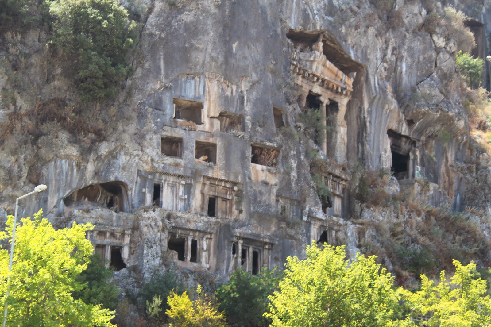
As ancient Lycia's most important city Telmessos ('the land of lights') from the 5th Century B.C., historical relics abound such as the tombs seen on the hills (including the Tomb of Amyntas) , the Hellenistic theatre near the marina and the sarcophagi in the middle of the street! Either as Telmessos or Anastasioupolis, as it was also known it has variably been part of the Persian empire, the Attic-Delos Union, Alexander the Great's empire, the Roman then Byzantine empire, until it became Ottoman after the late 12th century. It has been known for its perfume production, and for having a sizeable Greek population before the population exchange.
Now a major tourist hub, with several stunning beaches (such as Oludeniz, supposedly the most photographed in the Mediterranean, and Chalish), pretty harbors and bays, ancient Lycian cities and the famous Lycian Way walking path, sailing opportunities, market stalls, small villages (including the ghost village a Karakoy) and resorts. With the Taurus Mountains rising up as a backdrop to the calm turquoise waters, and an ideal temperature and climate, its popularity is not surprising.

 It is easy to see what this magnificent natural formation is a UNESCO World Heritage Site. It has inspired and sustained legends and while there are similar formations (like Fingal's Cave on Scottish isle Staffa on the other side of the sea), it is unique. At most 12 meters high and around 28 meters thick in the widest places, they were formed during a volcanic eruption during the Paleogene period 50-60 million years ago as the lava cooled near the limestone forming a similar structure to dried, cracked mud. However, the stones just form part of a 3800 square kilometer area including the surrounding 100m cliffs, which form the largest remaining lava plateau in Europe.